The ABJ's lede today is the announcement that Akron will host a "wireless internet access corridor" under a plan unveiled yesterday. The Knight Foundation is granting $4.5 million to the nonprofit digital networking organization OneCommunity to set up the network. OneCommunity will set up the Knight Center for Digital Excellence to run the network. In addition, the Center will be part of a broader effort to expand community wireless access. This from the press release:
- The nonprofit Knight Center of Digital Excellence will collect and
share international best practices online with communities everywhere. It
will provide on-the-ground aid to the Knight communities to develop
technology strategies and enable citizens to connect with each other and
the world. Knight's initiative includes a $10 million Digital Opportunity
fund offering challenge grants to Knight communities.
You can watch the press conference on Knight's site. Case Wester CIO and blogger Lev Gonick blogs about the presser here (h/t BFD. Gonick is also a OneCommunity co-founder.)
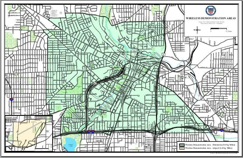
Ohio dot com hosts a pdf map of the area to be covered. With less functionality, we offer this:

This is very much about central city with a clear focus being business development. The area is bordered roughly by Memorial Parkway/Tallmadge Ave on the north, Route 8 and Exchange Street on the east, South and Fifth streets on the south and Mercer and Storer Ave on the west. While plenty of residential areas are included, much of what is excluded is residential. Most of the wealthiest (Northwest where the rubber mansions stand) and poorest (especially Summit Lake) areas are just beyond the coverage area.
More thoughts later.


2 comments:
I haven't lived in Akron for twenty-five years, so what do I know?... but it looks like most of the neighborhoods that are historically "the poorest" (East Akron, near North Side, West Hill, Opportunity Park) are on the map. I guess it's fair to say this is "the central city", but not in the sense of "downtown". I think you'll find that the resulting user partnerships are just as much about health care and public education applications as about business development.
More to the point, as with One Community's other community mesh project surrounding CWRU, the model is to enlist a big fiber-rich 1C-affilated institution as the anchor, and build the wireless mesh out in a circle around it. The mesh can then grow through fairly cheap increments around the edges.
Bill:
As far as neighborhoods, it is, as I said, a mixed bag. Many of the poorest neighborhoods are in fact about half in and half out.
It makes more sense given the ability to incrementally build out the network without major expenditure.
And I don't mean any of this as criticism. It's more in line with looking at what the consortium is trying to do. Looking at the map, it appears they are trying to offer core city WiFi as a part of business infrastructure.
Post a Comment